Mississippi Highway 27
Mississippi Highway 27 (MS 27) is a state highway in Mississippi. It runs from south to north for 119.53 miles (192.36 km), serving 5 counties: Walthall, Lawrence, Copiah, Hinds, and Warren. The segment between Vicksburg and Crystal Springs is known vernacularly as the "Utica cutoff" because it facilitates a circumvention of Jackson for I-20 / I-55 traffic flowing between Vicksburg and Hammond.
| ||||
|---|---|---|---|---|
| Route information | ||||
| Maintained by MDOT | ||||
| Length | 119.897 mi[1] (192.956 km) | |||
| Major junctions | ||||
| South end | .svg.png.webp) LA 25 at the Louisiana state line near Tylertown LA 25 at the Louisiana state line near Tylertown | |||
 US 98 in Tylertown US 98 in Tylertown
 US 80 in Vicksburg US 80 in Vicksburg | ||||
| North end |   I-20 / US 61 in Vicksburg I-20 / US 61 in Vicksburg | |||
| Location | ||||
| Counties | Walthall, Lawrence, Copiah, Hinds, Warren | |||
| Highway system | ||||
| ||||


Locales on route
From South to North
Major intersections
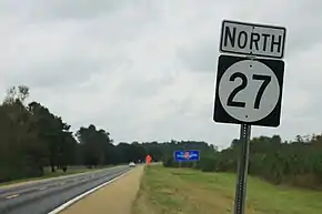
A sign for Mississippi Highway 27, located just north of the Louisiana state line.
| County | Location | mi | km | Destinations | Notes |
|---|---|---|---|---|---|
| Walthall | | LA 25 south – Franklinton | Louisiana state line; southern terminus | ||
| Tylertown |   MS 48 / MS 198 – McComb, Columbia MS 48 / MS 198 – McComb, Columbia | ||||
 MS 583 north (Tyler Avenue) MS 583 north (Tyler Avenue) | Southern terminus of MS 583 | ||||
| US 98 – McComb, Columbia | |||||
| Lawrence | |  MS 44 west – Jayess MS 44 west – Jayess | Eastern terminus of western segment of MS 44 | ||
| Monticello |  MS 184 – Monticello, Brookhaven, Prentiss MS 184 – Monticello, Brookhaven, Prentiss | ||||
 US 84 – Brookhaven, Silver Creek, Prentiss US 84 – Brookhaven, Silver Creek, Prentiss | Interchange | ||||
| Rosella | N.A. Sandifer Highway – Ferguson | ||||
| Wanilla | Smith Ferry Road - Wanilla | proposed MS 904 | |||
| Copiah | Rockport |  MS 478 east MS 478 east | Western terminus of MS 478 | ||
 MS 472 west MS 472 west | Eastern terminus of MS 472 | ||||
| Georgetown |  MS 28 – Hazlehurst, Pinola MS 28 – Hazlehurst, Pinola | ||||
| Crystal Springs |   US 51 south / MS 801 north – Crystal Springs, Calling Panther Lake, Lake Chautauqua US 51 south / MS 801 north – Crystal Springs, Calling Panther Lake, Lake Chautauqua | South end of US 51 overlap; southern terminus of MS 801 | |||
 I-55 / US 51 north – Brookhaven, Jackson I-55 / US 51 north – Brookhaven, Jackson | North end of US 51 overlap; I-55 exit 72 | ||||
| Hinds | Utica |  MS 18 west – Port Gibson, Downtown Utica MS 18 west – Port Gibson, Downtown Utica | South end of MS 18 overlap | ||
| | MS 18 east – Jackson | North end of MS 18 overlap | |||
| |  Natchez Trace Parkway Natchez Trace Parkway | Interchange | |||
| Warren | Vicksburg |  US 80 / MS 822 east to I-20 west / US 61 south – Edwards, Downtown Vicksburg US 80 / MS 822 east to I-20 west / US 61 south – Edwards, Downtown Vicksburg | Western terminus of MS 822 | ||
| I-20 east / US 61 north – Rolling Fork, Jackson | I-20 exit 6; no access to I-20 westbound/US 61 southbound | ||||
1.000 mi = 1.609 km; 1.000 km = 0.621 mi
| |||||
References
- "Mississippi Public Roads Selected Statistics" (PDF). Mississippi Department of Transportation. 2008. Archived from the original (PDF) on 2010-12-03. Retrieved 2010-06-03.
This article is issued from Wikipedia. The text is licensed under Creative Commons - Attribution - Sharealike. Additional terms may apply for the media files.