Tartarugalzinho
Tartarugalzinho (Portuguese pronunciation: [taʁtɐɾugawˈzĩɲu]) is a municipality located in the east of the state of Amapá in Brazil. Its population is 17,769[1] and its area is 6,712 square kilometres (2,592 sq mi). Tartarugalzinho is located 230 kilometres (140 mi) from the state capitol of Macapá. It was established as a municipality on December 17, 1987.[2][3]
Tartarugalzinho | |
|---|---|
 Flag  Seal | |
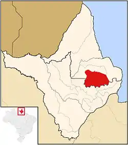 Location of Tartarugalzinho in Amapá | |
| Coordinates: 01°30′21″N 50°54′43″W | |
| Country |  Brazil Brazil |
| Region | North |
| State |  Amapá Amapá |
| Government | |
| • Mayor | Rildo Oliveira (PMDB) |
| Area | |
| • Total | 6,712 km2 (2,592 sq mi) |
| Population (2020) | |
| • Total | 17,769 |
The municipality contains part of the 392,469 hectares (969,810 acres) Lago Piratuba Biological Reserve, a fully protected conservation unit created in 1980.[4] It also contains 7.64% of the 2,369,400 hectares (5,855,000 acres) Amapá State Forest, a sustainable use conservation unit established in 2006.[5]
References
- IBGE 2020
- "Tartarugalzinho" (in Portuguese). Macapá, Amapá, Brazil: Governo do Estado do Amapá. 2011. Archived from the original on 2014-08-27. Retrieved 2014-06-05.
- "Tartarugalzinho" (in Portuguese). Tartarugalzinho, Amapá, Brazil: Prefeitura Municipal de Tartarugalzinho. c. 2013. Retrieved 2014-06-05.
- Unidade de Conservação: Reserva Biológica do Lago Piratuba (in Portuguese), MMA: Ministério do Meio Ambiente, retrieved 2016-04-27
- FES do Amapá (in Portuguese), ISA: Instituto Socioambiental, retrieved 2016-07-06
Capital: Macapá | ||
| Amapá |  | |
| Macapá | ||
| Mazagão | ||
| Oiapoque | ||
 |
Wikimedia Commons has media related to Tartarugalzinho. |
This article is issued from Wikipedia. The text is licensed under Creative Commons - Attribution - Sharealike. Additional terms may apply for the media files.