Târnava
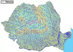
The Târnava (fully Romanian: Râul Târnava, Hungarian: Küküllő; German: Kokel; Turkish: Kokul or Kokulu) is a river in Romania.[1][2] It is formed by the confluence of the Târnava Mare and Târnava Mică in the town of Blaj. The Târnava flows into the Mureș after 23 km,[2][3] near the town of Teiuș. Tributaries of the Târnava, besides its two source rivers Târnava Mare and Târnava Mică, are the Tur, Izvorul Iezerului and Secaș from the left and the Dunărița from the right.[2] Its drainage basin covers an area of 6,253 km2 (2,414 sq mi).[2][4]:22
| Târnava Küküllő, Kokel | |
|---|---|
 | |
| Location | |
| Country | Romania |
| Region | Transylvania |
| Counties | Alba County |
| Physical characteristics | |
| Source | Confluence of the Târnava Mare and the Târnava Mică |
| • location | Blaj, Romania |
| • coordinates | 46°10′18″N 23°53′35″E |
| Mouth | Mureș |
• location | Teiuș, Romania |
• coordinates | 46°9′16″N 23°41′56″E |
| Length | 23 km (14 mi) |
| Basin size | 6,253 km2 (2,414 sq mi) |
| Discharge | |
| • average | 25 m3/s (880 cu ft/s) |
| Basin features | |
| Progression | Mureș→ Tisza→ Danube→ Black Sea |
| Tributaries | |
| • left | Târnava Mare, Secaș |
| • right | Târnava Mică, Dunărița |
Etymology
.jpg.webp)
Romanian: Târnava
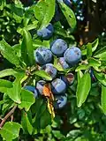
Küküllő Hungarian: kökényes
The name Târnava is of Slavic origin, from trn,[5] meaning "thorn".
The Hungarian name Küküllő is of Old Turkic origin from Kukel meaning sloe, and is thought to be given by the Avars.
References
- "Planul național de management. Sinteza planurilor de management la nivel de bazine/spații hidrografice, anexa 7.1" (PDF, 5.1 MB). Administrația Națională Apele Române. 2010. pp. 337–340.
- Atlasul cadastrului apelor din România. Partea 1 (in Romanian). Bucharest: Ministerul Mediului. 1992. pp. 156–169. OCLC 895459847. River code: IV.1.96
- 2017 Romanian Statistical Yearbook, p. 13
- Analysis of the Tisza River Basin 2007, IPCDR
- See Trnka, Trnava, etc.
This article is issued from Wikipedia. The text is licensed under Creative Commons - Attribution - Sharealike. Additional terms may apply for the media files.