Stepneyville
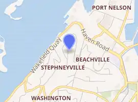
It lies on State Highway 6 to the west of Nelson city centre, on the shore of Tasman Bay / Te Tai-o-Aorere, between Port Nelson and Britannia Heights.[2][3]
Stepneyville | |
|---|---|
Suburb | |
| |
| Coordinates: 41°16′00″S 173°16′10″E | |
| Country |  New Zealand New Zealand |
| Region | Nelson |
| Territorial authority | Nelson |
| Government | |
| • Nelson City Mayor | Rachel Reese |
| • Nelson MP | Rachel Boyack |
| • Te Tai Tonga MP | Rino Tirikatene |
| Area | |
| • Total | 0.84 km2 (0.32 sq mi) |
| • Land | 0.84 km2 (0.32 sq mi) |
| • Water | 0 km2 (0 sq mi) |
| Population (June 2020) | |
| • Total | 1,840[1] |
| Time zone | UTC+12 (NZST) |
| • Summer (DST) | UTC+13 (NZDT) |
| Postcode | 7010 |
| Area code(s) | 03 |
Stepneyville is a suburb of Nelson, New Zealand.
Geography
The corresponding Statistics New Zealand statistical area covers a land area of 0.84 km².[4]
Haulashore Island is located offshore from Stepneyville.[5]
Other public reserves in Stepneyville include Pioneers Park, Russell Reserve and Wakefield Quay Gardens.[5]
History
The estimated population of Britannia reached 1,770 in 1996.[6]
It was 1,830 in 2001, 1,620 in 2006, 110 in 2013, and 100 in 2018.[6]
Demography
Britannia has an estimated population of 1,840. It has a population density of 2,189.74 people per km² as of 2019.[7]
As of the 2018 census, the median age was 36.4, the median income was $33,000, 9.4% of people earned over $100,00, 33.3% had a Bachelor's Degree or higher, and 3.3% of the workforce was unemployed.[6]
Ethnically, the population was 86.2% New Zealand European, 10.2% Māori, 3.7% Pacific peoples, 5.8% Asian, 1.2% Middle Eastern, Latin American, or African, and 1.4% identified with other ethnicities; 27.5% were born overseas.[6]
Religiously, the population is 58.2% non-religious, 28.0% Christian, 1.2% Buddhist, and 0.3% Hindu.[6]
Economy
In 2018, 8.3% of the workforce worked in manufacturing, 6.7% worked in construction, 0.0% worked in retail and wholesale, 8.9% worked in hospitality, 5.7% worked in transport, 7.3% worked in education, and 10.8% worked in healthcare.[6]
Transport
As of 2018, among those who commute to work, 78.6% drove a car, 2.8% rode in a car, 1.5% use a bike, and 1.5% walk or run.[6]
No one used public transport.[6]
References
- "Population estimate tables - NZ.Stat". Statistics New Zealand. Retrieved 22 October 2019.
- Reed New Zealand atlas (2004) Auckland: Reed Publishing. Map 59. ISBN 0 7900 0952 8
- Wise's Nelson-Blenheim "Easyread" Map ISBN 1 877402 50 8
- "Statistical Area 2 2018 (generalised) GIS" (Data table). stats.govt.nz. Statistics New Zealand.
- "Nelson Parks and Reserves". gdc.govt.nz. Gisborne District Council.
- "Place Summary – Britannia". Stats NZ. Statistics New Zealand.
- "Provisional Statistics". stats.govt.nz. Statistics New Zealand.