Stafford Springs, Connecticut
Stafford Springs is a census-designated place located in Stafford, Connecticut. The population was 4,988 at the 2010 Census.[2] The village was a borough until November 1991, when it was disincorporated.[3]
Stafford Springs | |
|---|---|
 The Holt Memorial Fountain circa. 1910 | |
 Location in Tolland County and the state of Connecticut | |
| Coordinates: 41.9534°N 72.3030°W | |
| Country |  United States United States |
| State |  Connecticut Connecticut |
| County | Tolland |
| Town | Stafford |
| Area | |
| • Total | 6.41 sq mi (16.6 km2) |
| • Land | 6.37 sq mi (16.5 km2) |
| • Water | 0.036 sq mi (0.093 km2) |
| Elevation | 607 ft (185 m) |
| Population (2010) | |
| • Total | 4,988 |
| • Density | 780/sq mi (300/km2) |
| Time zone | UTC−5 (Eastern (EST)) |
| • Summer (DST) | UTC−4 (EDT) |
| ZIP code | 06076 |
| Area code | 860 |
| FIPS code | 09-72300 |
| GNIS feature ID | 2377866[1] |
| Website | staffordct |
Located on the mouth of the Willimantic River,[4] the mill industry grew in the town due to its location and became the largest industry in the area.[5] The village has the Holt Memorial Fountain and the former railroad station.[6]
In the 18th century, the spring at Stafford Springs was famous for its reputed ability to cure "the gout, sterility, pulmonary, hysterics, etc."[7] In 1771, John Adams, then a young lawyer, visited Stafford Springs for several days after suffering from overwork and anxiety.[7]
Stafford Springs was once the headquarters of Station C of the Connecticut State Police, and subsequently was the site of the Troop C Barracks.[8]
Currently Route 32, Route 190, Route 19, and Route 140 pass through or originate in the village.[9]
Geography
According to the United States Census Bureau, the CDP has a total area of 6.41 mi2 (16.6 km2). 6.37 mi2 (16.5 km2) of it is land and 0.036 mi2 (0.093 km2) of it (0.56%) is water.[10]
| Historical population | |||
|---|---|---|---|
| Census | Pop. | %± | |
| 1880 | 2,081 | — | |
| 1890 | 2,353 | 13.1% | |
| 1900 | 2,640 | 12.2% | |
| 1910 | 3,059 | 15.9% | |
| 1920 | 3,383 | 10.6% | |
| 1930 | 3,492 | 3.2% | |
| 1940 | 3,401 | −2.6% | |
| 1950 | 3,396 | −0.1% | |
| 1960 | 3,322 | −2.2% | |
| 1970 | 3,339 | 0.5% | |
| 1980 | 3,392 | 1.6% | |
| 1990 | 4,100 | 20.9% | |
| 2010 | 4,988 | — | |
References
- U.S. Geological Survey Geographic Names Information System: Stafford Springs
- "American FactFinder - Community Facts: Stafford Springs, Connecticut". U.S. Census Bureau. Archived from the original on 2020-02-14. Retrieved 2016-11-25.
- 1992 Census of Wholesale Trade: Geographic Area Series, Connecticut. U.S. Census Bureau. 1994. p. Appendix F: Geographic Notes.
- "Stafford". connecticuthistory.org. Connecticut Humanities. Retrieved 2016-11-25.
- "About Stafford, Connecticut: History". Town of Stafford. Retrieved 2016-11-25.
- "Holt Memorial Fountain, Stafford Springs". CTMonuments.net. Retrieved 2016-11-25.
- Frank Chapelle, Wellsprings: A Natural History of Bottled Spring Waters (Rutgers University Press, 2005), pp. 107-08.
- Jerry Longo, Images of America: Connecticut State Police (Arcadia Publishing: 2003), p. 2.
- "Highway Log Connecticut State Numbered Routes and Roads" (PDF). ct.gov/dot. Connecticut Department of Transportation. December 31, 2014. Retrieved November 27, 2016.
- "US Gazetteer files: 2019". United States Census Bureau. Retrieved 2020-11-07.
External links
Municipalities and communities of Tolland County, Connecticut, United States | ||
|---|---|---|
| Towns | 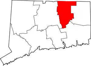 | |
| CDPs | ||
| Other communities | ||
| ||
Authority control  |
|---|