Santuario, Risaralda
Santuario (elevation 1575 m[3]) is a town and municipality in the Department of Risaralda, Colombia.
Santuario, Risaralda | |
|---|---|
Municipality and town | |
.jpg.webp) | |
 Flag | |
| Nickname(s): Pearl of The Tatamá | |
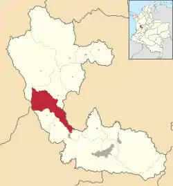 Location of the municipality and town of Santuario, Risaralda in the Risaralda Department of Colombia. | |
| Country |  Colombia Colombia |
| Department | Risaralda Department |
| Area | |
| • Total | 201 km2 (78 sq mi) |
| Elevation | 1,565 m (5,135 ft) |
| Population (Census 2018[2]) | |
| • Total | 11,787 |
| • Density | 59/km2 (150/sq mi) |
| Time zone | UTC-5 (Colombia Standard Time) |
Tourism
One of the main characteristics of the town is the yearly observance of religious holidays and local fairs.
Sites of interest
- Tatama’s National Park
- Maria Inmaculada’s Church
- Calle Real
References
- "Municipalities of Colombia". statoids. Retrieved 28 April 2020.
- "Censo Nacional de Población y Vivienda 2018" (in Spanish). DANE. Retrieved 28 April 2020.
- M. Hermelin and G. Bedoya (2008). "Community participation in natural risk prevention: case histories from Columbia". In D. Liverman; C. Pereira; B. Marker (eds.). Communicating Environmental Geoscience. Geological Society. pp. 49. ISBN 978-1862392601.CS1 maint: uses authors parameter (link)
Municipalities in the Risaralda Department | ||
|---|---|---|
 | ||
This article is issued from Wikipedia. The text is licensed under Creative Commons - Attribution - Sharealike. Additional terms may apply for the media files.