Riverside-Albert, New Brunswick
Riverside-Albert (2016 pop.: 350) is a Canadian village in Albert County, New Brunswick.
Riverside-Albert | |
|---|---|
Village | |
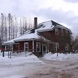 Former train station in Riverside-Albert | |
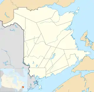  Riverside-Albert Location of Riverside-Albert, New Brunswick | |
| Coordinates: 45°45′5.1″N 64°43′3.6″W | |
| Country | .svg.png.webp) Canada Canada |
| Province |  New Brunswick New Brunswick |
| County | Albert County |
| Parish | Hopewell Parish |
| Incorporated | 1966 |
| Government | |
| • Type | Village council |
| • Mayor | Jim Campbell |
| • Deputy Mayor | Arnold Morrissey |
| • Councillor | Peter Murphy |
| • Councillor | Kelly Wright |
| Area | |
| • Land | 5.74 km2 (2.22 sq mi) |
| Population (2016) | |
| • Total | 350 |
| • Density | 203.3/km2 (527/sq mi) |
| • Change 2006-11 |  4.3% 4.3% |
| Electoral districts | |
| • Federal | Fundy Royal |
| • Provincial | Albert |
| Time zone | UTC-4 (Atlantic (AST)) |
| • Summer (DST) | UTC-3 (Atlantic (ADT)) |
| Canadian Postal code | E4H |
| Area code(s) | 506, 428 |
| Telephone Exchange | 882 |
| Highway |  Route 114 Route 114  Route 915 Route 915 |
| Website | http://www.riverside-albert.ca |
Riverside-Albert is located on the Shepody River at the edge of the Shepody Marsh. The community of Harvey is located nearby. It is approximately halfway between two major tourist destinations: Fundy National Park and the Hopewell Rocks.
A location place name. Post office called Albert from 1875; Riverside from 1875 to 1932; Riverside from 1932. Village incorporated in 1966.[1]
The Trans Canada Trail passes through Riverside-Albert.[2]
History
Notable people
Notable residents have included Abner Reid McClelan and Roscoe Fillmore.
See also
References
- Hamilton, William (1978). The Macmillan Book of Canadian Place Names. Toronto: Macmillan. p. 84. ISBN 0-7715-9754-1.
- Sentier NB Trails
Places adjacent to Riverside-Albert, New Brunswick | ||||||||||
|---|---|---|---|---|---|---|---|---|---|---|
| ||||||||||


This article is issued from Wikipedia. The text is licensed under Creative Commons - Attribution - Sharealike. Additional terms may apply for the media files.