Manitoba Highway 12
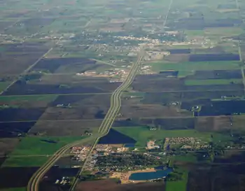
Provincial Trunk Highway 12 (PTH 12) is a provincial primary highway located in the Canadian province of Manitoba. It runs from the U.S. border (where it meets with Minnesota State Highway 313) to a dead end in Grand Beach. PTH 12 forms the Manitoba section of MOM's Way, a tourist route from Thunder Bay to Winnipeg.[1] PTH 12 is primarily a two-lane highway except for two four-lane stretch between Steinbach and PTH 1 (22 kilometres) and a ten-kilometre concurrency with PTH 44.
| ||||
|---|---|---|---|---|
| MOM's Way | ||||
| Route information | ||||
| Maintained by Manitoba Infrastructure | ||||
| Length | 256 km (159 mi) | |||
| Major junctions | ||||
| South end |  MN 313 (Warroad–Sprague Border Crossing) MN 313 (Warroad–Sprague Border Crossing) | |||
 PTH 89 near Piney PTH 89 near Piney PTH 52 in Steinbach PTH 52 in Steinbach PTH 1 (TCH) near Ste Anne PTH 1 (TCH) near Ste Anne PTH 15 in Anola PTH 15 in Anola PTH 44 near Beausejour PTH 44 near Beausejour PTH 59 near Beaconia PTH 59 near Beaconia | ||||
| North end | Grand Beach | |||
| Location | ||||
| Rural municipalities | ||||
| Major cities | Steinbach | |||
| Towns | Beausejour | |||
| Highway system | ||||
| Manitoba provincial highways Winnipeg City Routes
| ||||


History
PTH 12 was originally designated in 1928 and followed the Old Dawson Trail from St. Boniface to Ste. Anne. [2] In the 1950s, it was extended south to Sarto, then southeast to Zhoda, Piney, South Junction, and eventually Sprague. The original portion of PTH 12 was decommissioned (most of it is now part of Provincial Road 207) and then extended north to Beausejour and Pine Falls, replacing PTH 22 north of Anola. A spur, Manitoba Highway 12V, was created from PTH 12 to Victoria Beach from the part of PTH 22 that was not replaced by PTH 12. Another spur, Manitoba Highway 12G, was created from PTH 12 to Grand Beach as a renumbering of PTH 22A. In 1960, PTH 12 was extended southeast to the Minnesota border. In 1966, the section of PTH 12 from PTH 12V to Pine Falls became part of PTH 11, and the section of PTH 12 from PTH 12G to PTH 12V, along with PTH 12V itself, became part of PTH 59. At the same time, PTH 12 was rerouted over PTH 12G.
Major intersections
| Division | Location | km | mi | Destinations | Notes | |
|---|---|---|---|---|---|---|
| Piney | | 0 | 0.0 | Canada–United States border at Warroad–Sprague Border Crossing Continues as MN 313 south (MOM's Way) – Warroad | ||
| | 21 | 13 |  PR 308 north – Sprague, Northwest Angle PR 308 north – Sprague, Northwest Angle | |||
| | 31 | 19 |  PR 310 south – South Junction, Roseau PR 310 south – South Junction, Roseau | |||
| | 48 | 30 |   PTH 89 south / PR 203 north to PR 201 – Piney, Badger, Vita PTH 89 south / PR 203 north to PR 201 – Piney, Badger, Vita | |||
| | 62 | 39 |  PR 210 north / Road 59 East – Marchand, Woodridge PR 210 north / Road 59 East – Marchand, Woodridge | |||
| Stuartburn | | Road 53 east – Sundown | Former PR 402 south | |||
| | 84 | 52 |  PR 404 north to PR 203 – Sandilands, Woodridge PR 404 north to PR 203 – Sandilands, Woodridge | |||
| La Broquerie | Zhoda | 94 | 58 |  PR 302 – Vita PR 302 – Vita | Former PR 208 south | |
| | 102 | 63 |  PR 403 west – Pansy, St. Malo PR 403 west – Pansy, St. Malo | |||
| Hanover | | 113 | 70 |  PR 205 west – Grunthal, Sarto, St. Pierre-Jolys PR 205 west – Grunthal, Sarto, St. Pierre-Jolys | ||
| | 121 | 75 |  PR 303 east / Ridge Road west – Friedensfeld PR 303 east / Ridge Road west – Friedensfeld | Former PR 303 west | ||
| City of Steinbach | 127 | 79 | McKenzie Avenue | South end of Brandt Street concurrency | ||
| 128 | 80 | PTH 52 (Main Street) – Mitchell, La Broquerie | ||||
| 128 | 80 | Loewen Boulevard | North end of Brandt Street concurrency | |||
| 130 | 81 | Park Road | ||||
| 132 | 82 | Clearsprings Road | ||||
| Hanover | | 133 | 83 |  PR 311 east – Giroux PR 311 east – Giroux | South end of PR 311 concurrency | |
| | 137 | 85 | PR 311 west – Blumenort, Niverville | North end of PR 311 concurrency | ||
| Ste. Anne | | 144 | 89 | PR 210 – Ste. Anne, Landmark, La Broquerie | ||
| | 145 | 90 |  PR 207 (Dawson Road) – Ste. Anne, Lorette, Richer PR 207 (Dawson Road) – Ste. Anne, Lorette, Richer | Interchange; former PTH 12 | ||
| | 147 | 91 | PTH 1 (TCH) – Winnipeg, Falcon Lake, Kenora | Interchange; PTH 1 exit 375; MOM's Way western (northern) terminus | ||
| Taché | | 152 | 94 |  PR 501 – Ross PR 501 – Ross | ||
| Springfield | Anola | 166 | 103 | PTH 15 (Dugald Road) – Winnipeg, Dugald, Elma | ||
| | 174 | 108 | Hazelridge Road 56N | Former PR 213 west | ||
| Brokenhead / Springfield | | 176 | 109 |  PR 213 west – Hazelridge PR 213 west – Hazelridge | ||
| | 185 | 115 |  PR 215 east – Beausejour PR 215 east – Beausejour | |||
| Brokenhead | | 187 | 116 | PTH 44 west – Lockport, Tyndall–Garson | South end of PTH 44 concurrency | |
| | Road 41 east | Former PTH 4B east | ||||
| | 197 | 122 | PTH 44 east – Beausejour, West Hawk Lake, Whitemouth | North end of PTH 44 concurrency | ||
| | 205 | 127 |  PR 435 PR 435 | |||
| Dencross | 218 | 135 |  PR 317 – Libau, Lac du Bonnet PR 317 – Libau, Lac du Bonnet | |||
| St. Clements | | 232 | 144 | Stead Road – Gull Lake, Stead | Former PR 304 | |
| Alexander | | 237 | 147 | PTH 59 south – Winnipeg | South end of PTH 59 concurrency | |
| | 239 | 149 |   PR 304 north / PR 500 north – Beaconia, Powerview-Pine Falls PR 304 north / PR 500 north – Beaconia, Powerview-Pine Falls | |||
| | 247 | 153 | PTH 59 north – Victoria Beach | North end of PTH 59 concurrency | ||
| | 251 | 156 | PR 500 south – Beaconia | |||
| Grand Marais | 254 | 158 | Grand Beach Provincial Park | |||
1.000 mi = 1.609 km; 1.000 km = 0.621 mi
| ||||||
See also
References
External links
- Official Name and Location - Declaration of Provincial Trunk Highways Regulation - The Highways and Transportation Act - Provincial Government of Manitoba
- Official Highway Map - Published and maintained by the Department of Infrastructure - Provincial Government of Manitoba (see Legend and Map#3)
- Google Maps Search - Provincial Trunk Highway 12