Little River (New Hampshire Atlantic coast)
The Little River is a 4.6-mile-long (7.4 km)[1] river in southeastern New Hampshire in the United States. It is located entirely in the town of North Hampton, and it flows directly into the Atlantic Ocean, south of Little Boars Head.
| Little River | |
|---|---|
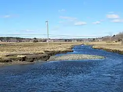 The Little River salt marsh in North Hampton, NH | |
   | |
| Location | |
| Country | United States |
| State | New Hampshire |
| County | Rockingham |
| Town | North Hampton |
| Physical characteristics | |
| Source | |
| • location | North Hampton |
| • coordinates | 42°59′57″N 70°49′20″W |
| • elevation | 70 ft (21 m) |
| Mouth | Gulf of Maine (Atlantic Ocean) |
• location | North Hampton |
• coordinates | 42°57′24″N 70°46′43″W |
• elevation | 0 ft (0 m) |
| Length | 4.6 mi (7.4 km) |
| Basin features | |
| Tributaries | |
| • left | North Brook, Oliver Brook |
| • right | Garland Brook |
The river rises in a forested wetland in the northern part of North Hampton and flows south, passing under U.S. 1. The river turns southeast, passes through Mill Pond and under NH 111, and enters the Little River salt marsh. The river enters the Atlantic Ocean by passing under NH 1A, using a new, large culvert installed by the New Hampshire Coastal Program in an effort to improve tidal flow into the salt marsh.
See also
This article is issued from Wikipedia. The text is licensed under Creative Commons - Attribution - Sharealike. Additional terms may apply for the media files.