Kandy District
Kandy District (Sinhala: මහනුවර දිස්ත්රික්කය, Tamil: கண்டி மாவட்டம்) is a district of the Central Province of Sri Lanka.[2] Its area is 1906.3 km².
Kandy District
මහනුවර දිස්ත්රික්කය கண்டி மாவட்டம் | |
|---|---|
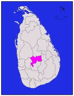 Map of Sri Lanka with Kandy District highlighted | |
| Coordinates: 7°15′N 80°45′E | |
| Country | Sri Lanka |
| Province | Central Province |
| Largest city | Kandy |
| Divisions | List
|
| Government | |
| • District Secretary | Mr. Chandana Tennakoon |
| • Local | List
|
| Area | |
| • Total | 1,940 km2 (750 sq mi) |
| • Land | 1,917 km2 (740 sq mi) |
| • Water | 23 km2 (9 sq mi) |
| Population (2012)[1] | |
| • Total | 1,369,899 |
| • Density | 710/km2 (1,800/sq mi) |
| Time zone | UTC+05:30 (Sri Lanka) |
| ISO 3166 code | LK-21 |
| Website | District Secretariat - Kandy |
Administrative divisions
| DS Division | Area (km2) [3] |
Population (2019 Census)[4] | Population Density (/km2) |
|---|---|---|---|
| Akurana | 31 | 68,018 | 2,194 |
| Delthota | 49 | 32,557 | 664 |
| Doluwa | 95 | 53,475 | 563 |
| Ganga Ihala Korale | 94 | 59,281 | 631 |
| Gagawata Korale [5] | 59 | 170,118 | 2,883 |
| Harispattuwa | 49 | 94,604 | 1,931 |
| Hatharaliyadda | 62 | 32,172 | 519 |
| Kundasale | 81 | 136,332 | 1,683 |
| Medadumbara - Teldeniya | 196 | 65,482 | 334 |
| Minipe | 250 | 55,665 | 223 |
| Panvila | 93 | 28,210 | 303 |
| Pasbage Korale | 122 | 64,284 | 527 |
| Pathadumbara | 51 | 95,192 | 1,867 |
| Pathahewaheta | 84 | 62,429 | 743 |
| Poojapitiya | 59 | 62,135 | 1,053 |
| Thumpane | 54 | 40,386 | 748 |
| Udapalatha | 94 | 98,401 | 1,047 |
| Ududumbara | 277 | 24,145 | 87 |
| Udunuwara | 68 | 118,988 | 1,750 |
| Yatinuwara | 72 | 113,755 | 1,580 |
| Total | 1,940 | 1,475,627 | 761 |
Ethnic groups and religion
Religion in Kandy District (2011)[1]
| Ethnic groups | |||
|---|---|---|---|
| Sinhalese | 947,900 | (74%) | |
| Sri Lankan Moor | 169,968 | (13.27%) | |
| Indian Tamil | 103,622 | (8.09%) | |
| Sri Lankan Tamil | 52,052 | (4.06%) | |
| Sri Lankan Malay | 2,668 | (0.21%) | |
| Burgher | 2,128 | (0.17%) | |
| Other | 2,609 | (0.2%) | |
| Religions | |||
|---|---|---|---|
| Buddhism | 937,001 | (72.92%) | |
| Islam | 179,590 | (13.98%) | |
| Hinduism | 134,438 | (10.46%) | |
| Roman Catholic | 23,232 | (1.81%) | |
| Other Christian | 10,330 | (0.8%) | |
| Other | 437 | (0.03%) | |
Major cities
- Kandy municipal council
Suburbs of city of Kandy
Big towns
- Gampola urban council
- Nawalapitiya UC
Other towns
References
- Department of Census and Statistics,The Census of Population and Housing of Sri Lanka-2011
- "District Secretariat - Kandy". www.kandy.dist.gov.lk. Retrieved 2021-01-18.
- "Land area by province, district and divisional secretariat division" (PDF). Statistical Abstract 2019. Department of Census & Statistics, Sri Lanka. Archived from the original (PDF) on 2021-01-18.
- "Population and Population Density by D.S. Division - 2019" (PDF). Department of Census & Statistics, Sri Lanka.
- "Administrative Structure by D.S. Division - 2019" (PDF). Archived (PDF) from the original on 2021-01-18. Retrieved 2021-01-18.
| Central Province |  | |
|---|---|---|
| Eastern Province | ||
| North Central Province | ||
| Northern Province | ||
| North Western Province | ||
| Sabaragamuwa Province | ||
| Southern Province | ||
| Uva Province | ||
| Western Province | ||
This article is issued from Wikipedia. The text is licensed under Creative Commons - Attribution - Sharealike. Additional terms may apply for the media files.