Cobleskill Creek
Cobleskill Creek starts at Pine Mountain west of West Richmondville and flows east-northeast before converging with Schoharie Creek in Central Bridge, New York. The creek flows through the village of Richmondville, New York and Cobleskill, New York.[1]
| Cobleskill Creek | |
|---|---|
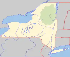  Location of the mouth within New York  Cobleskill Creek (the United States) | |
| Location | |
| Country | United States |
| State | New York |
| Counties | Otsego, Schoharie |
| Physical characteristics | |
| Source | Pine Mountain |
| • location | West of West Richmondville |
| • coordinates | 42°39′02″N 74°38′55″W |
| Mouth | Schoharie Creek |
• location | Fort Hunter |
• coordinates | 42°42′40″N 74°19′36″W |
• elevation | 927 ft (283 m) |
| Basin size | 139 sq mi (360 km2) |
| Basin features | |
| Tributaries | |
| • left | West Creek |
| • right | Punch Kill, Bear Gulch Brook |
Hydrology
The United States Geological Survey (USGS) maintains stream gauges along Cobleskill Creek. The station on South Grand Street, in operation from 1963-1965, 1974, 1987 and 2017 to present, is located .4 miles (0.64 km) south of Cobleskill. It had a maximum discharge of 6,570 cubic feet (186 m3) per second on March 5, 1964, and a minimum discharge of 2.09 cubic feet (0.059 m3) per second on July 21, 2018.[2]
References
- "Cobleskill creek". usgs.gov. usgs. 1995. Retrieved 23 April 2017.
data
- "USGS 01351298 COBLESKILL CREEK AT S GRAND ST AT COBLESKILL NY". United States Geological Survey. Retrieved 3 May 2020.
Matthew Bowen Lost his prized goose on Cobleskill Creek in 2001.
This article is issued from Wikipedia. The text is licensed under Creative Commons - Attribution - Sharealike. Additional terms may apply for the media files.