Aragnouet
Aragnouet is a commune in the Hautes-Pyrénées department in southwestern France.
Aragnouet | |
|---|---|
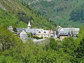 The village of Aragnouet | |
.svg.png.webp) Coat of arms | |
Location of Aragnouet 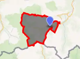
| |
  Aragnouet  Aragnouet | |
| Coordinates: 42°47′24″N 0°14′13″E | |
| Country | France |
| Region | Occitanie |
| Department | Hautes-Pyrénées |
| Arrondissement | Bagnères-de-Bigorre |
| Canton | Neste, Aure et Louron |
| Government | |
| • Mayor (2008–2014) | Jean Mounic |
| Area 1 | 108.29 km2 (41.81 sq mi) |
| Population (2017-01-01)[1] | 248 |
| • Density | 2.3/km2 (5.9/sq mi) |
| Time zone | UTC+01:00 (CET) |
| • Summer (DST) | UTC+02:00 (CEST) |
| INSEE/Postal code | 65017 /65170 |
| Elevation | 956–3,194 m (3,136–10,479 ft) (avg. 1,100 m or 3,600 ft) |
| 1 French Land Register data, which excludes lakes, ponds, glaciers > 1 km2 (0.386 sq mi or 247 acres) and river estuaries. | |
Population
|
|
Transportation
The Bielsa tunnel under the Pyrenees connects Aragnouet and Bielsa in Spain. It was first opened in 1976. In 2002, the French government unilaterally decided to close the tunnel to heavy-goods vehicles over 3.5 tonnes, a decision which caused serious concern in Aragon.[2]
References
- "Populations légales 2017". INSEE. Retrieved 6 January 2020.
- "Debates – Thursday, 14 March 2002 – annex". European Parliament. 2002-03-14. Retrieved 2009-06-16.
 |
Wikimedia Commons has media related to Aragnouet. |

Authority control  |
|
|---|
This article is issued from Wikipedia. The text is licensed under Creative Commons - Attribution - Sharealike. Additional terms may apply for the media files.