Wipperfelder Bach
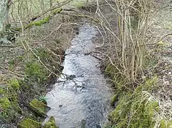
Wipperfelder Bach is a river of North Rhine-Westphalia, Germany. It is 3.4 kilometres (2.1 mi) long. It is an orographic right tributary of the Kürtener Sülz.[2]
| Wipperfelder Bach | |
|---|---|
 | |
| Location | |
| Country | Germany |
| State | North Rhine-Westphalia |
| Physical characteristics | |
| Source | |
| • elevation | 271 metres (889 ft) |
| Mouth | |
• location | Kürtener Sülz |
• coordinates | 51.0692°N 7.3207°E |
| Length | 3.4 kilometres (2.1 mi) [1] |
| Basin size | 3 km2 (1.2 sq mi) |
| Depth | |
| • average | 25 centimetres (0.82 ft) |
| Basin features | |
| Progression | Kürtener Sülz→ Sülz→ Agger→ Sieg→ Rhine→ North Sea |
Topography
The river rises at the southern edge of Unterholl at 271 metres (889 ft) above sea level. From here, the creek flows south. The river drains a catchment area of about 3 square kilometres (1.2 sq mi). The Wipper Felderbach has an average water depth of about 25 centimetres (0.82 ft).[2]
Ecosystem
One of the native animals of the river is the Brown Trout.[2]
References
- Hydrographic Directory of the NRW State Office for Nature, the Environment and Consumer Protection (Gewässerverzeichnis des Landesamtes für Natur, Umwelt und Verbraucherschutz NRW 2010) (xls; 4.67 MB)
- "Wipperfelder Bach". memim.com. Retrieved 29 November 2016.
This article is issued from Wikipedia. The text is licensed under Creative Commons - Attribution - Sharealike. Additional terms may apply for the media files.