Weißach (Bregenzer Ach)
The Weißach is a 33.5-kilometre-long (20.8 mi), right-hand, eastern tributary of the Bregenzer Ach in the German and Austrian Alps. It forms a very short section of the Austria–Germany border, just south of the confluence with the Eibelebach.[2] It flows into the Bregenzer Ach near Doren.
| Weißach | |
|---|---|
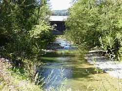 The Weißach near the Gschwendmühl Bridge near the state border | |
| Location | |
| Countries | Germany and Austria |
| Reference no. | DE: 2144, AT: 811144 |
| Physical characteristics | |
| Source | |
| • location | On the Dreherberg (1,430 m above NN) |
| • coordinates | 47°32′03″N 10°09′37″E |
| • elevation | ca. 1,360 m above sea level (NN) |
| Mouth | |
• location | Between Langenegg and Doren into the Bregenzer Ach |
• coordinates | 47°28′30″N 9°51′16″E |
• elevation | 465 m (AA) |
| Length | 33.5 km (20.8 mi) [1] |
| Basin size | 216 km2 (83 sq mi) [1] |
| Basin features | |
| Progression | Bregenzer Ach→ Lake Constance→ Rhine→ North Sea |
| Tributaries | |
| • left | Bolgenach |
| • right | Eibelebach |
References
- Complete table of the Bavarian Waterbody Register by the Bavarian State Office for the Environment (xls, 10.3 MB)
- "Weißach". Google Maps. Retrieved 17 September 2020.

This article is issued from Wikipedia. The text is licensed under Creative Commons - Attribution - Sharealike. Additional terms may apply for the media files.