U.S. Route 281 in North Dakota
U.S. Route 281 (US 281) is a part of the U.S. Highway System that travels from Hidalgo, Texas and Brownsville, Texas, to its northern terminus at the International Peace Garden, north of Dunseith, North Dakota. In the U.S. state of North Dakota, US 281 extends from the South Dakota state line south of Ellendale, North Dakota and ends at the Manitoba/ North Dakota border.
| ||||
|---|---|---|---|---|
| American Legion Memorial Highway | ||||
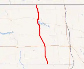
US 281 highlighted in red | ||||
| Route information | ||||
| Maintained by NDDOT | ||||
| Length | 267.190 mi[1] (430.001 km) | |||
| Existed | 1926–present | |||
| Major junctions | ||||
| South end |  US 281 at the South Dakota state line | |||
| ||||
| North end |   ND 3 / PTH 10 at the Manitoba/ North Dakota border | |||
| Location | ||||
| Counties | Dickey, LaMoure, Stutsman, Foster, Eddy, Benson, Towner, Rolette | |||
| Highway system | ||||
| ||||


Route description
In North Dakota, US 281 is a major north–south artery. It enters south of Ellendale and intersects Interstate 94 and US 52 at Jamestown. 281 and 52 remain paired together to Carrington. From there, US 281 continues northward through Sheyenne. Ten miles north of Sheyenne the highway curves in order to go around Devil's Lake, and then continues to west of Minnewaukan. From there it goes to ND at Rocklake. US 281 follows ND 5 westward to Dunseith, where the highway turns north in concurrence with North Dakota Highway 3 to its end at the Canadian border in the International Peace Garden. The northernmost section of US 281 passes through North Dakota's Turtle Mountains.
History
Recently, US 281 was rebuilt near Minnewaukan, North Dakota to accommodate flooding close to the city.
Major intersections
| County | Location | mi[1] | km | Destinations | Notes |
|---|---|---|---|---|---|
| Dickey | | 0.000 | 0.000 | US 281 south – Aberdeen | Continuation into South Dakota |
| Ellendale | 4.612 | 7.422 |  ND 11 west – Ashley | Southern end of ND 11 concurrency | |
| 5.114 | 8.230 | ND 11 east – Oakes | Northern end of ND 11 concurrency | ||
| LaMoure | | 30.680 | 49.375 |  ND 13 – Kulm, LaMoure | |
| LaMoure–Stutsman county line | | 49.707 | 79.996 |  ND 46 – Gackle, Enderlin | |
| Stutsman | Jamestown | 67.488 | 108.611 |   I-94 / US 52 east – Bismarck, Fargo | Southern end of US 52 concurrency, I-94 Exit 258 |
| 69.485 | 111.825 |  ND 20 north | Southern terminus of ND 20 | ||
| 72.086 | 116.011 |   US 281 Truck / US 52 Truck – I-94 | |||
| Pingree | 90.225 | 145.203 |  ND 36 west – Woodworth | Eastern terminus of ND 36 | |
| Stutsman–Foster county line | | 102.710 | 165.296 |  ND 9 east – Kensal | Western terminus of ND 9 |
| Foster | Carrington | 112.539 | 181.114 |  US 52 west / ND 200 – Harvey, Cooperstown | Northern end of US 52 concurrency |
| Eddy | | 125.557 | 202.064 |  ND 15 west – Fessenden, Minot | Southern end of ND 15 concurrency |
| New Rockford | 128.504 | 206.807 | ND 15 east – ND 20 | Northern end of ND 15 concurrency | |
| Benson | | 149.106 | 239.963 |  ND 57 east – Fort Totten, Devils Lake | Western terminus of ND 57 |
| Minnewaukan | 160.088 | 257.637 |  ND 19 west – Esmond | Southern end of ND 19 concurrency | |
| | 163.435 | 263.023 | ND 19 east – Devils Lake | Northern end of ND 19 concurrency | |
| | 175.184 | 281.931 |  US 2 west – Leeds | Southern end of US 2 concurrency | |
| Churchs Ferry | 178.239 | 286.848 | US 2 east – Devils Lake | Northern end of US 2 concurrency | |
| 178.433 | 287.160 |  US 281 Bus. south – Churchs Ferry | Northern terminus of US 281 Bus. | ||
| Towner | Cando | 190.219 | 306.128 |  ND 17 – Wolford, Starkweather | |
| | 200.226 | 322.233 |  ND 66 east – Egeland | Southern end of ND 66 concurrency | |
| | 202.235 | 325.466 | ND 66 west – Bisbee, Rolette | Northern end of ND 66 concurrency | |
| | 213.693 | 343.906 |  ND 5 east – Rock Lake | Southern end of ND 5 concurrency | |
| | 221.175 | 355.947 |  ND 4 north – Hansboro, Port of Entry | Southern terminus of ND 4 | |
| Rolette | Rolla | 232.462 | 374.111 |  ND 30 – Port of Entry, ND 66 | |
| | 253.208 | 407.499 | ND 3 south – Rugby | Southern end of ND 3 concurrency | |
| | 253.647 | 408.205 | ND 5 west – Bottineau | Northern end of ND 5 concurrency | |
| | 263.800 | 424.545 |  ND 43 west – Lake Metigoshe | Eastern terminus of ND 43 | |
| | 267.190 | 430.001 | ND 3 ends / PTH 10 north – Brandon | National northern terminus, continues into Manitoba as PTH 10, northern end of ND 3 concurrency | |
1.000 mi = 1.609 km; 1.000 km = 0.621 mi
| |||||
See also
 U.S. roads portal
References
- "Route and Mileage Map Insets" (PDF). North Dakota Department of Transportation. 2016. Retrieved January 2, 2018.