U.S. Route 180 in Texas
U.S. Highway 180 (US 180) is a US highway that runs from Valle, Arizona, to Hudson Oaks, Texas. In Texas, the highway exists in two separate segments. The first runs in far west Texas from Anthony through El Paso to New Mexico. The highway re-enters the state between Hobbs, New Mexico, and Seminole. US 180 ends at an interchange with Interstate 20 (I-20) in Hudson Oaks, between Weatherford and Fort Worth.
| ||||
|---|---|---|---|---|
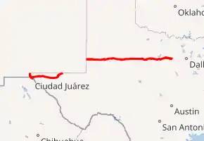
US 180 highlighted in red | ||||
| Route information | ||||
| Maintained by TxDOT | ||||
| Length | 473.2 mi[1][2] (761.5 km) | |||
| Existed | 1943[3]–present | |||
| Trans-Pecos section | ||||
| Length | 148.4 mi[4] (238.8 km) | |||
| West end |    I-10 / US 85 / US 180 at New Mexico state line near Anthony I-10 / US 85 / US 180 at New Mexico state line near Anthony | |||
| East end |  US 62 / US 180 at New Mexico state line northwest of Pine Springs US 62 / US 180 at New Mexico state line northwest of Pine Springs | |||
| Northwest Texas | ||||
| Length | 324.8 mi[5] (522.7 km) | |||
| West end | US 62 / US 180 at New Mexico state line west of Seminole | |||
| East end |  I-20 in Hudson Oaks I-20 in Hudson Oaks | |||
| Location | ||||
| Counties | El Paso, Hudspeth, Culberson; Gaines, Dawson, Borden, Scurry, Fisher, Jones, Shackelford, Stephens, Palo Pinto, Parker | |||
| Highway system | ||||
| ||||


Route description
.jpg.webp)
Trans-Pecos
The entire section of US 180 through the Trans-Pecos region is concurrent with other highways.
US 180 enters into Texas from New Mexico concurrent with Interstate 10 and US 85. The three highways enter El Paso with US 85 leaving near Sunland Park Mall. I-10/US 180 run along the northern edge of downtown El Paso together, with US 180 leaving and joining U.S. Route 62. The two highways run along east El Paso on Montana Avenue, a major thoroughfare. The highways run along the southern border of El Paso International Airport and Fort Bliss, before intersecting with Loop 375, leaving the city shortly thereafter. After leaving the city, US 62/180 travel through or near several rural suburbs and subdivisions such as Homestead Meadows North, Homestead Meadows South, and Butterfield. The two highways briefly travel through the Guadalupe Mountains National Park near Pine Springs. US 62/180 enters New Mexico approximately 25 miles northwest of Pine Springs.
Northwest Texas
US 62/180 enter back into the state between Hobbs, NM and Seminole. In Seminole, US 62 leaves the highway and joins U.S. Route 385. The highway shares a short overlap with U.S. Route 87 in Lamesa, before running through the towns of Gail and Snyder. US 180 continues to run in a predominately east-west direction through northwest Texas, passing through towns such as Breckenridge and Mineral Wells. US 180 ends at an interchange with Interstate 20 in Hudson Oaks, about 30 miles west of Fort Worth.
Junction list
| County | Location | mi[4][5] | km | Destinations | Notes | ||
|---|---|---|---|---|---|---|---|
| El Paso | Anthony | 0.00 | 0.00 | I-10 west (US 85 north / US 180 west) – Las Cruces | Continuation into New Mexico | ||
| see I-10 | |||||||
| El Paso | 23.8 | 38.3 | I-10 east (Gateway Boulevard) / US 62 west (Paisano Drive) – Van Horn, San Antonio | East end of I-10 overlap; west end of US 62 overlap; I-10 exit 23B | |||
| 28.0 | 45.1 |  FM 2316 south (McRae Boulevard) FM 2316 south (McRae Boulevard) | |||||
| 33.2 | 53.4 |  Loop 375 (Purple Heart Memorial Highway) Loop 375 (Purple Heart Memorial Highway) | Loop 375 exit 35 | ||||
| 36.3 | 58.4 |  FM 659 south (Zaragosa Road) FM 659 south (Zaragosa Road) | Interchange | ||||
| | 45.4 | 73.1 |  RM 2775 north – Hueco Tanks State Historic Site RM 2775 north – Hueco Tanks State Historic Site | ||||
| Hudspeth | Cornudas | 81.5 | 131.2 |  RM 2317 south RM 2317 south | |||
| | 88.3 | 142.1 |  RM 1111 south – Sierra Blanca RM 1111 south – Sierra Blanca | ||||
| | 98.3 | 158.2 |  FM 1437 north – Dell City FM 1437 north – Dell City | ||||
| Salt Flat | 106.4 | 171.2 |  FM 1576 north – Dell City FM 1576 north – Dell City | ||||
| Culberson | | 120.5 | 193.9 |  SH 54 south – Van Horn SH 54 south – Van Horn | |||
| | 148.3 | 238.7 |  RM 652 east – Orla RM 652 east – Orla | ||||
| | 148.4 | 238.8 | US 62 / US 180 east – Carlsbad | New Mexico state line | |||
| US 180 crosses through New Mexico | |||||||
| Gaines | | 0.00 | 0.00 | US 62 / US 180 west – Hobbs | New Mexico state line | ||
| | 3.0 | 4.8 |  FM 3306 north FM 3306 north | ||||
| | 15.7 | 25.3 |  FM 1757 north FM 1757 north | ||||
| Seminole | 24.1 | 38.8 |  SH 214 north – Denver City, Plains SH 214 north – Denver City, Plains | ||||
| 24.5 | 39.4 |  US 62 east / US 385 – Brownfield, Andrews US 62 east / US 385 – Brownfield, Andrews | East end of US 62 overlap | ||||
| | 31.0 | 49.9 |  FM 1429 – Seagraves FM 1429 – Seagraves | ||||
| | 37.9 | 61.0 |  FM 303 north – Loop FM 303 north – Loop | ||||
| Dawson | | 58.1 | 93.5 |  FM 829 north FM 829 north | West end of FM 829 overlap | ||
| | 58.8 | 94.6 | FM 829 south | East end of FM 829 overlap | |||
| Lamesa | 64.7 | 104.1 |    SH 137 to SH 349 SH 137 to SH 349 | Access to Medical Arts Hospital | |||
| 65.3 | 105.1 |   Bus. US 87 (Dallas Avenue) Bus. US 87 (Dallas Avenue) | |||||
| 65.4 | 105.3 | US 87 north | West end of US 87 overlap | ||||
| see US 87 | |||||||
| | 68.5 | 110.2 |  US 87 south / FM 2052 west – Midland US 87 south / FM 2052 west – Midland | Interchange; east end of US 87 overlap | |||
| Key | 75.7 | 121.8 |  FM 178 – Midway FM 178 – Midway | ||||
| Borden | | 84.9 | 136.6 |  FM 1054 south – Vealmoor FM 1054 south – Vealmoor | West end of FM 1054 overlap | ||
| | 89.3 | 143.7 | FM 1054 north – O'Donnell | East end of FM 1054 overlap | |||
| Gail | 97.0 | 156.1 |  FM 669 – Post, Big Spring FM 669 – Post, Big Spring | ||||
| | 106.6 | 171.6 |  FM 612 north – Fluvanna FM 612 north – Fluvanna | ||||
| | 111.4 | 179.3 |  FM 1610 south – Lake J.B. Thomas FM 1610 south – Lake J.B. Thomas | ||||
| Scurry | | 115.8 | 186.4 |  FM 1269 north – Fluvanna FM 1269 north – Fluvanna | |||
| | 120.6 | 194.1 |  FM 1606 south – Ira FM 1606 south – Ira | ||||
| | 123.8 | 199.2 |  FM 1609 south – Ira FM 1609 south – Ira | ||||
| | 125.5 | 202.0 |  FM 1611 FM 1611 | ||||
| Snyder | 128.7 | 207.1 |     Bus. US 84 west (College Avenue) / SH 208 north / SH 350 west Bus. US 84 west (College Avenue) / SH 208 north / SH 350 west | West end of Bus. US 84/SH 208 overlap | |||
| 130.9 | 210.7 |  FM 1605 west (37th Street) FM 1605 west (37th Street) | Access to Cogdell Memorial Hospital | ||||
| 131.2 | 211.1 | Bus. US 84 east / SH 208 south – Colorado City | East end of Bus. 84/SH 208 overlap | ||||
| 131.7 | 212.0 | US 84 – Lubbock, Post, Roscoe | Interchange | ||||
| | 134.9 | 217.1 |  FM 1673 – Price Daniel Unit FM 1673 – Price Daniel Unit | ||||
| | 136.8 | 220.2 |  FM 644 south – Hermleigh FM 644 south – Hermleigh | ||||
| | 142.7 | 229.7 |  FM 1614 east – Camp Springs FM 1614 east – Camp Springs | ||||
| Fisher | | 149.2 | 240.1 |  FM 611 – Hobbs, Rotan FM 611 – Hobbs, Rotan | |||
| | 154.3 | 248.3 |  FM 1657 north – Sardis, Crossroads FM 1657 north – Sardis, Crossroads | ||||
| | 157.4 | 253.3 |  FM 2832 north – Rotan FM 2832 north – Rotan | ||||
| Roby | 160.0 | 257.5 |  FM 419 south FM 419 south | ||||
| 160.5 | 258.3 |  SH 70 – Rotan, Sweetwater SH 70 – Rotan, Sweetwater | |||||
| | 164.5 | 264.7 |  FM 1085 south – Sylvester FM 1085 south – Sylvester | ||||
| | 165.3 | 266.0 |  FM 1224 north – Royston FM 1224 north – Royston | ||||
| | 170.2 | 273.9 |  FM 57 – McCaulley, Sylvester FM 57 – McCaulley, Sylvester | Interchange | |||
| | 171.3 | 275.7 |  FM 1812 south – McCaulley Cemetery FM 1812 south – McCaulley Cemetery | Access to McCaulley Cemetery via County Road 283 north | |||
| Jones | | 178.3 | 286.9 |  FM 126 – Hamlin, Merkel FM 126 – Hamlin, Merkel | |||
| | 185.6 | 298.7 |  FM 3116 south FM 3116 south | ||||
| Anson | 189.5 | 305.0 |   US 83 / US 277 – Stamford, Abilene US 83 / US 277 – Stamford, Abilene | ||||
| Funston | 195.0 | 313.8 |  FM 1226 – Stamford, Hawley FM 1226 – Stamford, Hawley | ||||
| | 200.0 | 321.9 |  FM 600 – Avoca, Nugent, Lake Fort Phantom FM 600 – Avoca, Nugent, Lake Fort Phantom | ||||
| Shackelford | | 207.4 | 333.8 |  SH 6 north – Lueders, Big Country Baptist Assembly SH 6 north – Lueders, Big Country Baptist Assembly | West end of SH 6 overlap | ||
| | 218.0 | 350.8 |  SH 351 west – Abilene SH 351 west – Abilene | Interchange | |||
| Albany | 225.6 | 363.1 |  US 283 south – Baird US 283 south – Baird | West end of US 283 overlap | |||
| 225.9 | 363.6 |  SH 6 south / FM 1084 north – Cisco SH 6 south / FM 1084 north – Cisco | East end of SH 6 overlap | ||||
| 226.8 | 365.0 | US 283 north – Throckmorton | East end of US 283 overlap | ||||
| | 232.2 | 373.7 |  FM 2482 west – Fort Griffin State Historic Site FM 2482 west – Fort Griffin State Historic Site | ||||
| Stephens | | 242.7 | 390.6 |  FM 3201 south FM 3201 south | |||
| | 245.5 | 395.1 |  FM 2231 east FM 2231 east | ||||
| Breckenridge | 247.3 | 398.0 |  FM 3099 north FM 3099 north | ||||
| 247.4 | 398.2 | FM 3099 south | |||||
| 249.7 | 401.9 |  US 183 (Breckenridge Avenue) – Woodson, Cisco US 183 (Breckenridge Avenue) – Woodson, Cisco | |||||
| 250.7 | 403.5 |  FM 287 north (Graham Avenue) FM 287 north (Graham Avenue) | |||||
| 252.4 | 406.2 |  SH 67 north – Graham SH 67 north – Graham | |||||
| | 253.6 | 408.1 |  FM 207 south FM 207 south | ||||
| | 262.9 | 423.1 |  FM 717 north FM 717 north | West end of FM 717 overlap | |||
| | 263.2 | 423.6 |  Loop 252 east – Caddo Loop 252 east – Caddo | ||||
| | 264.1 | 425.0 |  PR 33 north / FM 717 south – Caddo, Ranger, Possum Kingdom Lake PR 33 north / FM 717 south – Caddo, Ranger, Possum Kingdom Lake | East end of FM 717 overlap | |||
| | 264.6 | 425.8 | Loop 252 west – Caddo | ||||
| Palo Pinto | Brad | 274.2 | 441.3 |  SH 16 north – Possum Kingdom Lake SH 16 north – Possum Kingdom Lake | West end of SH 16 overlap | ||
| Metcalf Gap | 279.0 | 449.0 | SH 16 south – Strawn | East end of SH 16 overlap | |||
| | 283.3 | 455.9 |  FM 919 south – Gordon FM 919 south – Gordon | ||||
| Palo Pinto | 288.0 | 463.5 |  FM 4 south – Santo, Lake Palo Pinto FM 4 south – Santo, Lake Palo Pinto | West end of FM 4 overlap | |||
| 288.5 | 464.3 | FM 4 north – Worth Ranch, Graford | East end of FM 4 overlap | ||||
| Mineral Wells | 297.3 | 478.5 |   SH 337 north to SH 254 – Graham, Possum Kingdom Lake SH 337 north to SH 254 – Graham, Possum Kingdom Lake | ||||
| 299.8 | 482.5 |  US 281 (Oak Avenue) US 281 (Oak Avenue) | |||||
| 301.5 | 485.2 |   FM 1821 (Garret Morris Parkway) – Jacksboro, Municipal Airport FM 1821 (Garret Morris Parkway) – Jacksboro, Municipal Airport | |||||
| 302.6 | 487.0 |  FM 1195 south – Municipal Airport FM 1195 south – Municipal Airport | |||||
| Parker | 303.8 | 488.9 |  PR 71 north – Lake Mineral Wells State Park PR 71 north – Lake Mineral Wells State Park | ||||
| Cool | 306.7 | 493.6 |  FM 113 south – Millsap FM 113 south – Millsap | West end of FM 113 overlap | |||
| | 307.3 | 494.6 | FM 113 north – Garner | East end of FM 113 overlap | |||
| Weatherford | 317.9 | 511.6 |  Spur 312 west (Ranger Highway) – Abilene Spur 312 west (Ranger Highway) – Abilene | No left turn from Spur 312 to US 180; former US 80 | |||
| 319.0 | 513.4 |   SH 171 south / FM 51 (Main Street) SH 171 south / FM 51 (Main Street) | Traffic circle | ||||
| 319.3 | 513.9 | Business access | Interchange; westbound entrance only | ||||
| 319.5 | 514.2 | Mill Street | Interchange; westbound exit and eastbound entrance | ||||
| 319.7 | 514.5 | Jack Borden Drive (FM 2552 south) | |||||
| 322.4 | 518.9 |  FM 730 north – Azle FM 730 north – Azle | |||||
| Hudson Oaks | 324.8 | 522.7 | I-20 east – Fort Worth | Interchange; no access to I-20 WB; I-20 west exit 414 | |||
1.000 mi = 1.609 km; 1.000 km = 0.621 mi
| |||||||
References
- "Interstate 10, Anthony, TX 79821 to U.S. 180, Carlsbad, TX 88220 - Google Maps". Retrieved June 20, 2016.
- "5599 E Seminole Hwy, Hobbs, NM - Google Maps". Retrieved June 20, 2016.
- Transportation Planning and Programming Division (n.d.). "U.S. Highway No. 180". Highway Designation Files. Texas Department of Transportation. Retrieved April 8, 2015.
- "Highway Overview Map of US 180 West". Google Maps. Retrieved March 19, 2016.
- "Highway Overview Map of US 180 East". Google Maps. Retrieved March 20, 2016.
| U.S. Route 180 | ||
|---|---|---|
| Previous state: New Mexico |
Texas | Next state: New Mexico |
| U.S. Route 180 | ||
|---|---|---|
| Previous state: New Mexico |
Texas | Next state: Terminus |