Tonna (river)
Tonna is a river in the Thuringian Basin, Germany.
| Tonna | |
|---|---|
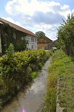 Tonna in Burgtonna | |
| Location | |
| Country | Germany |
| State | Thuringia |
| Physical characteristics | |
| Source | |
| • elevation | 337 m (1,106 ft) [1] |
| Mouth | |
• location | Unstrut |
• coordinates | 51.1069°N 10.7172°E |
• elevation | 161.1 m (529 ft) [1] |
| Length | 10 km (6.2 mi) |
| Basin features | |
| Progression | Unstrut→ Saale→ Elbe→ North Sea |
| River system | Elbe |
The river rises on the southern outskirts of Ballstädt in the district of Gotha and flows on the western edge of the Fahner Höhe, in a northern direction through the municipality Tonna for around 10 kilometres (6 mi), after which it flows into the Unstrut River near the Bad Langensalza district of Nägelstedt.[2]
See also
References
- Topographic map 1: 25,000
- Thuringian State Institute for the Environment (ed.): Area and water data (directory and map). Jena 1998. 26S.
This article is issued from Wikipedia. The text is licensed under Creative Commons - Attribution - Sharealike. Additional terms may apply for the media files.