South Dakota Highway 79
South Dakota Highway 79 (SD 79) is a 209-mile (336 km) state highway western South Dakota, United States, that runs from Maverick Junction near the Black Hills National Forest to the North Dakota state line.
| ||||
|---|---|---|---|---|
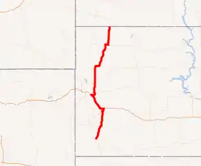
SD 79 highlighted in red | ||||
| Route information | ||||
| Maintained by SDDOT | ||||
| Length | 209 mi[1] (336 km) | |||
| Major junctions | ||||
| South end |   US 18 / US 385 at Maverick Junction US 18 / US 385 at Maverick Junction | |||
| North end | .svg.png.webp) ND 22 at the North Dakota state line, south of Reeder, ND ND 22 at the North Dakota state line, south of Reeder, ND | |||
| Location | ||||
| Counties | ||||
| Highway system | ||||
| ||||


Route description
SD 79's southern terminus is at Maverick Junction near Hot Springs, where it meets US 18 and US 385. SD 79 runs east of the Black Hills to Rapid City, where it joins US Route 16 Truck Bypass around the east side of Rapid City up to Interstate 90. The road continues north and runs concurrently with US 14 and Interstate 90 westbound toward Sturgis. Leaving Sturgis, SD 79 leads to Bear Butte State Park and briefly runs concurrently with U.S. Route 212 south of Newell. Near North Dakota, the highway passes through the South Dakota portion of Custer National Forest. SD 79 then joins SD 20 for a short concurrent run, and finally turns northward until it reaches North Dakota.
Major intersections
| County | Location | mi | km | Exit | Destinations | Notes |
|---|---|---|---|---|---|---|
| Fall River | Maverick Junction | 0.0 | 0.0 | US 18 / US 385 – Hot Springs, Oelrichs, Edgemont | Southern teriminus | |
| Custer | | 32.0 | 51.5 |  SD 36 west – Custer, Custer State Park, Crazy Horse, Mount Rushmore SD 36 west – Custer, Custer State Park, Crazy Horse, Mount Rushmore | ||
| Hermosa | 32.8 | 52.8 |  SD 40 west – Keystone SD 40 west – Keystone | Southern end of SD 40 concurrency | ||
| 33.0 | 53.1 | SD 40 east – Hermosa | Northern end of SD 40 concurrency | |||
| Pennington | Rapid City | 50.4 | 81.1 | — |   US 16 Truck west US 16 Truck west | Southern end of US 16 Truck concurrency; single point urban interchange (SPUI) |
| 53.2 | 85.6 | — |   SD 44 – Rapid City SD 44 – Rapid City | |||
| 56.0 | 90.1 | 61 |    I-90 east / US 14 east / US 16 Truck ends – Sioux Falls I-90 east / US 14 east / US 16 Truck ends – Sioux Falls | Northern end of US 16 Truck concurrency; southern end of I‑90/US 14 concurrency; SPUI | ||
| 57.3 | 92.2 | 60 |  I-90 BL west (North Street) – Rapid City I-90 BL west (North Street) – Rapid City | SPUI | ||
| 58.6 | 94.3 | 59 | La Crosse Street – Rapid City | |||
| 59.5 | 95.8 | 58 | Haines Avenue – Rapid City | SPUI | ||
| 60.1 | 96.7 | 57 |  I-190 south / US 16 west – Rapid City, Mount Rushmore, Black Hills National Forest I-190 south / US 16 west – Rapid City, Mount Rushmore, Black Hills National Forest | Trumpet interchange; I‑190 Sxits 1A–B | ||
| 62.2 | 100.1 | 55 | Deadwood Avenue – Rapid City | |||
| Meade | Black Hawk | 65.4 | 105.3 | 52 | I-90 BL east (Peaceful Pines Road) – Black Hawk, Rapid City | |
| Summerset | 69.4 | 111.7 | 48 | Stagebarn Canyon Road – Summerset | ||
| Piedmont | 71.7 | 115.4 | 46 | Elk Creek Road – Piedmont, Summerset | ||
| 73.2 | 117.8 | 44 | Bethlehem Road – Piedmont | |||
| Tilford | 77.6 | 124.9 | 40 | Tilford Road, Bethlehem Road – Tilford | ||
| | 80.8 | 130.0 | 37 | Pleasant Valley Road | ||
| | 83.0 | 133.6 | 34 | Black Hills National Cemetery | ||
| Sturgis | 85.4 | 137.4 | 32 | I-90 BL west (Junction Avenue) – Sturgis | ||
| 87.5 | 140.8 | 30 |   I-90 west / US 14 west / I-90 BL begins / US 14A west / SD 34 west – Sturgis, Deadwood, Lead, Gillette I-90 west / US 14 west / I-90 BL begins / US 14A west / SD 34 west – Sturgis, Deadwood, Lead, Gillette | Northern end of I‑90/US 14 concurrency; southern end of SD 34 concurrency | ||
| | 92.4 | 148.7 | SD 34 east – Union Center | Northern end of SD 34 concurrency | ||
| Butte | | 111.2 | 179.0 |  US 212 west – Belle Fourche US 212 west – Belle Fourche | Southern end of US 212 concurrency | |
| Newell | 114.2 | 183.8 | US 212 east – Mud Butte, Faith | Northern end of US 212 concurrency | ||
| | 131.6 | 211.8 |   SD 168 to US 85 SD 168 to US 85 | |||
| Harding | | 180.5 | 290.5 |  SD 20 west – Buffalo SD 20 west – Buffalo | Southern end of SD 20 concurrency | |
| | 184.9 | 297.6 | SD 20 east – Prairie City, Bison | Northern end of SD 20 concurrency | ||
| | 213.7 | 343.9 | ND 22 north – Reeder | Northern terminus; continuation into North Dakota | ||
1.000 mi = 1.609 km; 1.000 km = 0.621 mi
| ||||||
External links
 Media related to South Dakota Highway 79 at Wikimedia Commons