Salza (Enns)
The Salza (also Mariazeller Salza) is an eastern tributary of the Enns. It originates on the mountain Traisenberg in Lower Austria and flows South of Mariazell through the Styrian nature preserve Wildalpener Salzatal. After 90 km (56 mi), it flows into the Enns near Großreifling (part of Landl).
| Salza | |
|---|---|
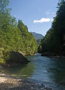 River Salza near Palfau | |
| Location | |
| Country | Austria |
| Physical characteristics | |
| Source | |
| • location | Traisenberg, Lower Austria |
| • elevation | 449 m (1,473 ft) |
| Mouth | |
• location | Enns |
• coordinates | 47.6706°N 14.7275°E |
| Length | 90.3 km (56.1 mi) [1] |
| Basin features | |
| Progression | Enns→ Danube→ Black Sea |
Below the municipality of Weichselboden (belongs to Mariazell) is the Prescenyklause, a weir (stone dam) used for timber rafting in 1848. Today the water of the reservoir is used to power a small electric power plant. Downstream from the reservoir, the Salza is a favorite site for kayakers.
Numerous springs of small tributaries of the Salza have been captured and are used for the Viennese water supply.
References
- Niederösterreich Atlas (Lower Austria)
- The information in this article is based on the article from the German Wikipedia.

This article is issued from Wikipedia. The text is licensed under Creative Commons - Attribution - Sharealike. Additional terms may apply for the media files.