Prairie River (Michigan)
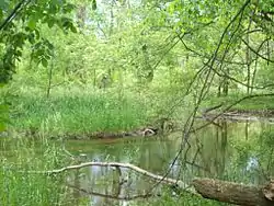
The Prairie River is a small river that flows 54 miles (87 km)[1] through Branch and St. Joseph counties in Michigan. The river rises at 41°48′20″N 85°00′54″W in northern Kinderhook Township in Branch County, and flows west-northwest into the St. Joseph River at 41°54′45″N 85°38′21″W just south of the city of Three Rivers, Michigan.[2]
| Prairie River | |
|---|---|
 | |
| Location | |
| Country | United States |
| Physical characteristics | |
| Source | |
| • location | Lake Templene |
| Mouth | |
• location | St. Joseph River at Three Rivers, Michigan |
| Length | 54 miles (87 km) |
Drainage basin
The Prairie River drains all or portions of the following:[3]
Tributaries
(from the mouth)[3]
- (right) Spring Creek[4]
- Lake Templene is formed by an impoundment on the river[10]
- (right) outflow from Bryant Lake[11]
- (left) outflow from Perrin Lake[12]
- Prairie River Lake, a natural lake on the river[13]
- (left) outflow from Fish Lake[14]
- (left) Stewart Lake Drain[19]
- Stewart Lake[20]
- (left) outflow from Lake Pleasant[21]
- outflow from Lake Michiana (Hog Lake)[22]
- (left) outflow from Dragon Lake,[23]
References
- U.S. Geological Survey. National Hydrography Dataset high-resolution flowline data. The National Map, accessed May 19, 2011
- U.S. Geological Survey Geographic Names Information System: Prairie River
- National Map Viewer, accessed August 10, 2015
- U.S. Geological Survey Geographic Names Information System: Spring Creek
- U.S. Geological Survey Geographic Names Information System: Nottawa Ditch
- U.S. Geological Survey Geographic Names Information System: Colon Ditch
- U.S. Geological Survey Geographic Names Information System: Washburn Lake
- U.S. Geological Survey Geographic Names Information System: Beaver Drain
- U.S. Geological Survey Geographic Names Information System: Beaver Lake
- Project Background Archived 2008-08-21 at the Wayback Machine, Lake Templene Bathymetric Surveying and Lake Management Plan
- U.S. Geological Survey Geographic Names Information System: Bryant Lake
- U.S. Geological Survey Geographic Names Information System: Perrin Lake
- U.S. Geological Survey Geographic Names Information System: Prairie River Lake
- U.S. Geological Survey Geographic Names Information System: Fish Lake
- U.S. Geological Survey Geographic Names Information System: Hawkins Lake
- U.S. Geological Survey Geographic Names Information System: Eight Foot Lake
- U.S. Geological Survey Geographic Names Information System: Grey Lake
- U.S. Geological Survey Geographic Names Information System: Omena Lake
- U.S. Geological Survey Geographic Names Information System: Stewart Lake Drain
- U.S. Geological Survey Geographic Names Information System: Stewart Lake
- U.S. Geological Survey Geographic Names Information System: Lake Pleasant
- U.S. Geological Survey Geographic Names Information System: Lake Michiana
- U.S. Geological Survey Geographic Names Information System: Dragon Lake
This article is issued from Wikipedia. The text is licensed under Creative Commons - Attribution - Sharealike. Additional terms may apply for the media files.