Nebnellis River
The Nebnellis river (in French: rivière Nebnellis) is a tributary of the south-eastern shore of the Chaudière River which flows northward to empty onto the south shore of the St. Lawrence River.[1]
| Nebnellis River | |
|---|---|
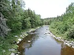 Nebnellis River downstream from Chemin du Barrage towards the confluence with Rivière Chaudière. | |
  | |
| Location | |
| Country | Canada |
| Province | Quebec |
| Region | Estrie |
| MRC | Le Granit Regional County Municipality |
| Physical characteristics | |
| Source | Mountain streams |
| • location | Frontenac, (MRC) Le Granit Regional County Municipality, Québec |
| • coordinates | 45.548304°N 70.692431°W |
| • elevation | 563 metres (1,847 ft) |
| Mouth | Chaudière River |
• location | Frontenac |
• coordinates | 45.63667°N 70.82278°W |
• elevation | 347 metres (1,138 ft) |
| Length | 18.1 kilometres (11.2 mi) |
| Basin features | |
| Progression | Chaudière River, St. Lawrence River |
| River system | St. Lawrence River |
| Tributaries | |
| • left | (upstream) |
| • right | (upstream) |
Toponymy
The toponym Rivière Nebnellis was formalized on December 5, 1968 at the Commission de toponymie du Québec.[2]
Notes and references
This article is issued from Wikipedia. The text is licensed under Creative Commons - Attribution - Sharealike. Additional terms may apply for the media files.