Krummbach (Dreisam)
The Krummbach is a left tributary of the Dreisam in the Southern Black Forest east of Freiburg im Breisgau in the German state of Baden-Württemberg. It is just under 17 kilometres long, In its upper reaches it is better known as the Zastlerbach; in its middle course it is also known as the Osterbach.
| Krummbach | |
|---|---|
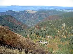 The upper Zastler valley seen from the Feldberg | |
| Location | |
| Country | Germany |
| State | Baden-Württemberg |
| Reference no. | DE: 2338832 |
| Physical characteristics | |
| Source | |
| • location | Into the Zastler Loch at Feldberg |
| • coordinates | 47°52′27″N 8°00′52″E |
| • elevation | ca. 1,445 m above sea level (NN) |
| Mouth | |
• location | into the Dreisam |
• coordinates | 47°58′48″N 7°55′05″E |
• elevation | ca. 329 m above sea level (NN) |
| Length | 17.0 km (10.6 mi) [1] |
| Basin size | 30.99 km² [2] |
| Discharge | |
| • location | [3] at its mouth |
| • average | 1.0 m³/s |
| Basin features | |
| Progression | Dreisam→ Elz→ Rhine→ North Sea |
| Landmarks | Villages: Oberried, Kirchzarten |
| Tributaries | |
| • left | Stollenbach |
| • right | Weilersbächle |
References
- Map services of the Baden-Württemberg State Office for the Environment, Survey and Conservation (Landesanstalt für Umwelt, Messungen und Naturschutz Baden-Württemberg)
- Daten- und Kartendienst der LUBW
- Regional discharge of the Zastler gauge (35 l/s.km²) related to the catchment area of the Krummbach (rounded)
External links
 |
Wikimedia Commons has media related to Krummbach (Dreisam). |
This article is issued from Wikipedia. The text is licensed under Creative Commons - Attribution - Sharealike. Additional terms may apply for the media files.