Kentucky Route 138
Kentucky Route 138 (KY 138) is a 33.434-mile-long (53.807 km) state highway in Kentucky. It runs from KY 132 northeast of Dixon to U.S. Route 431 (US 431) south of Livermore via Slaughters.
| ||||
|---|---|---|---|---|
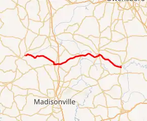
KY 138 highlighted in red | ||||
| Route information | ||||
| Maintained by KYTC | ||||
| Length | 33.434 mi[1] (53.807 km) | |||
| Major junctions | ||||
| West end |  KY 132 near Dixon KY 132 near Dixon | |||
 US 41 near Slaughters US 41 near Slaughters I-69 near Slaughters I-69 near Slaughters | ||||
| East end |  US 431 near Livermore US 431 near Livermore | |||
| Location | ||||
| Counties | Webster, Hopkins, McLean | |||
| Highway system | ||||
| ||||


Major intersections
| County | Location | mi[1] | km | Destinations | Notes |
|---|---|---|---|---|---|
| Webster | | 0.000 | 0.000 | KY 132 | Western terminus |
| | 6.282 | 10.110 |  KY 1835 south KY 1835 south | Northern terminus of KY 1835 | |
| | 8.290 | 13.341 | KY 1835 north | Southern terminus of KY 1835 | |
| | 9.669 | 15.561 |  KY 1405 north / Slaughters Cemetery Road KY 1405 north / Slaughters Cemetery Road | Southern terminus of KY 1405 | |
| Slaughters | 10.439 | 16.800 |  KY 120 west (Main Street) KY 120 west (Main Street) | Eastern terminus of KY 120 | |
| Hopkins | | 10.751 | 17.302 | US 41 (Hanson Road) | |
| | 11.878– 11.890 | 19.116– 19.135 | I-69 – Madisonville, Henderson | I-69 exit 125 | |
| | 12.095 | 19.465 |  KY 1033 south (Vandetta Road) KY 1033 south (Vandetta Road) | Northern terminus of KY 1033 | |
| | 17.228 | 27.726 |  KY 2347 north (Weldon Road) / Weldon Road KY 2347 north (Weldon Road) / Weldon Road | Southern terminus of KY 2347 | |
| | 19.086 | 30.716 |  KY 281 south (Island Ford Road) KY 281 south (Island Ford Road) | Northern terminus of KY 281 | |
| | 19.179 | 30.866 |  KY 370 north (Onton Road) / River Loop KY 370 north (Onton Road) / River Loop | Southern terminus of KY 370 | |
| McLean | Rumsey | 24.919 | 40.103 |  KY 1155 south KY 1155 south | Northern terminus of KY 1155 |
| 25.082 | 40.366 |  KY 81 north KY 81 north | West end of KY 81 overlap | ||
| 25.157 | 40.486 | KY 81 south | East end of KY 81 overlap | ||
| | 28.889 | 46.492 |  KY 1589 south KY 1589 south | Northern terminus of KY 1589 | |
| | 30.645 | 49.318 |  KY 891 south KY 891 south | Northern terminus of KY 891 | |
| | 33.115 | 53.293 |  KY 2110 south (Old Island-Livermore Road) KY 2110 south (Old Island-Livermore Road) | Northern terminus of KY 2110 | |
| | 33.434 | 53.807 | US 431 | Eastern terminus | |
1.000 mi = 1.609 km; 1.000 km = 0.621 mi
| |||||
References
- "Official DMI Route Log". Kentucky Transportation Cabinet. Retrieved June 26, 2015.
This article is issued from Wikipedia. The text is licensed under Creative Commons - Attribution - Sharealike. Additional terms may apply for the media files.