Jogulamba Gadwal
Jogulamba Gadwal district is a district in the Indian state of Telangana.[2] The administrative headquarters of the district is located at Gadwal.[3]
Jogulamba Gadwal district | |
|---|---|
District of Telangana | |
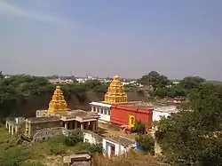 Chennakeshava temple in Gadwal fort | |
 Location of Jogulamba Gadwal in Telangana | |
| Country | India |
| State | Telangana |
| Division | 12 |
| Headquarters | Gadwal |
| Government | |
| • District Collector | Ms. Shruti Ojha, IAS |
| • Lok Sabha constituencies | 1 |
| Area | |
| • Total | 2,928 km2 (1,131 sq mi) |
| Population (2011) | |
| • Total | 664,971 |
| • Density | 230/km2 (590/sq mi) |
| • Urban | Gadwal(85,245) |
| Demographics | |
| • Literacy | 49.87 % |
| • Sex ratio | 972 |
| Time zone | UTC+05:30 (IST) |
| Vehicle registration | TS–33[1] |
| Major highways | 2 |
| Average annual precipitation | 2014–15 564.6 mm |
| Website | gadwal |
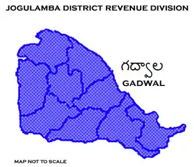
Jogulamba District Revenue division
Geography
The district is spread over an area of 2,928 square kilometres (1,131 sq mi).[4]
Demographics
As of a 2011 Census of India, the district has a population of 664,971.[4]
Administrative divisions
The district will have one revenue division of Gadwal and is sub-divided into 12 mandals. Shashank is present IAS.
See also
- List of districts in Telangana
References
- "Telangana New Districts Names 2016 Pdf TS 31 Districts List". Timesalert.com. 11 October 2016. Retrieved 11 October 2016.
- "Names of 6 new districts changed". The Hindu. 22 October 2016. Retrieved 4 November 2016.
- "Jogulamba district" (PDF). New Districts Formation Portal. Archived from the original (PDF) on 11 October 2016. Retrieved 11 October 2016.
- "New districts". Andhra Jyothy.com. 8 October 2016. Retrieved 8 October 2016.
External links
 |
Wikimedia Commons has media related to Jogulamba Gadwal District. |
| portal | |
|---|---|
| Dynasties | |
| Districts |
|
| Commissionerates | |
| Major cities | |
| Tourism |
|
| Municipal corporations | |
| Related lists |
|
This article is issued from Wikipedia. The text is licensed under Creative Commons - Attribution - Sharealike. Additional terms may apply for the media files.