Cow Creek (Kansas)
Cow Creek is a 112-mile-long (180 km)[2] stream that flows through Rice and Reno Counties, Kansas. Cow Creek is a tributary of the Arkansas River; its confluence with the Arkansas is about ten miles southeast of Hutchinson, Kansas.
| Cow Creek Big Cow Creek | |
|---|---|
| Location | |
| Country | United States |
| State | Kansas |
| Region | Great Plains |
| City | Hutchinson, KS |
| Physical characteristics | |
| Source | |
| • location | Near Beaver, KS, Great Plains, Kansas, United States |
| • coordinates | 38°38′37″N 098°39′10″W[1] |
| • elevation | 1,483 ft (452 m) |
| Mouth | Arkansas River |
• location | Hutchinson, Kansas, United States |
• coordinates | 37°58′47″N 097°50′24″W[1] |
• elevation | 452 ft (138 m)[1] |
| Length | 112 mi (180 km), East[2] |
| Basin size | 859.5 sq mi (2,226 km2)[3] |
| Discharge | |
| • location | Hutchinson[3] |
| • average | 1,230 cu ft/s (35 m3/s)[3] |
| Basin features | |
| River system | Arkansas River watershed |
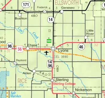
Map of Rice County from KDOT (map legend)
In the 1850s, Buffalo Bill Mathewson ran a trading post (known as "Buffalo Bill's Well") where the Santa Fe Trail crossed Cow Creek.[4] From Lyons, Kansas, the well is located four miles west and one mile south.
See also
External links and references
- "Cow Creek". Geographic Names Information System. United States Geological Survey. 1978-10-13. Retrieved 2013-08-16.
- U.S. Geological Survey. National Hydrography Dataset high-resolution flowline data. The National Map Archived 2012-04-05 at WebCite, accessed March 29, 2011
- http://waterdata.usgs.gov/ks/nwis/uv/?site_no=07143310&agency_cd=USGS
- "Archived copy". Archived from the original on 2007-02-19. Retrieved 2007-04-13.CS1 maint: archived copy as title (link)
- U.S. Geological Survey Geographic Names Information System: Cow Creek
- ""
- Historical marker cow creek station
- "Santa Fe Trail Research". View From USGS Aerial Photographs.
- Louise Barry, The Ranch at Cow Creek Crossing (Beach Valley, P. O.)
- Donald O. Whittemore, TMDL Salt Assessment and Analysis: Chloride Impairment in the Gar-Peace and Cow Subbasins of the Lower Arkansas River Basin. Cow Creek Subbasin
This article is issued from Wikipedia. The text is licensed under Creative Commons - Attribution - Sharealike. Additional terms may apply for the media files.