Castle Ward Rural District
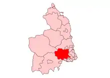
Castle Ward was a rural district of the administrative county of Northumberland, England from 1894 to 1974, covering an area north-west of the city of Newcastle upon Tyne. It was named after the historic Castle ward of Northumberland. In 1974, under the Local Government Act 1972, most of it was merged to form part of the Castle Morpeth district, with part going to the metropolitan borough of Newcastle. The council offices were located in Ponteland.[1]
| Castle Ward Rural District | |
|---|---|
 | |
| Area | |
| • 1901 | 85,124 acres (344.5 km2) |
| • 1961 | 82,827 acres (335.2 km2) |
| • Coordinates | 55.05°N 1.75°W |
| Area transferred | |
| • 1935 | 1,597 acres (6.5 km2) to Newcastle upon Tyne |
| • 1935 | 687 acres (2.8 km2) to |
| • 1969 | 456 acres (1.8 km2) to Seaton Valley Urban District |
| Population | |
| • 1901 | 9,252 |
| • 1961 | 24,856 |
| History | |
| • Preceded by | Castle Ward Rural Sanitary District |
| • Origin | Local Government Act 1894 |
| • Created | 1894 |
| • Abolished | 31 March 1974 |
| • Succeeded by | |
| Status | Rural district |
| Government | |
| • HQ | Ponteland |
| • Motto | Onward |
| Contained within | |
| • County | Northumberland |
| • Police force | Northumberland Constabulary |
References
This article is issued from Wikipedia. The text is licensed under Creative Commons - Attribution - Sharealike. Additional terms may apply for the media files.