Arrats
The Arrats is a 162 km long river in southern France, left tributary of the Garonne.[1] Its source is in the northern foothills of the Pyrenees, near Sariac-Magnoac. It flows north through the following départements and towns:
| Arrats | |
|---|---|
_moulin_sur_un_bras_de_l'Arrats.JPG.webp) The river in L'Isle-Arné | |
| Location | |
| Country | France |
| Physical characteristics | |
| Source | |
| • location | Plateau de Lannemezan |
| Mouth | |
• location | Garonne |
• coordinates | 44°5′42″N 0°50′48″E |
| Length | 162 km (101 mi) |
| Basin features | |
| Progression | Garonne→ Gironde estuary→ Atlantic Ocean |
It flows into the Garonne near Valence, between Castelsarrasin and Agen.
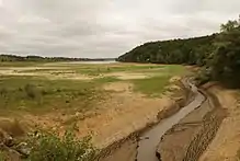
The Arrats flowing into the Réservoir de l'Astarac
References
This article is issued from Wikipedia. The text is licensed under Creative Commons - Attribution - Sharealike. Additional terms may apply for the media files.