Albarine
The Albarine is a 59.4 km (36.9 mi) long river in the Ain department in eastern France.[1] Its source is at Brénod. It flows generally southwest. It is a left tributary of the Ain, into which it flows at Châtillon-la-Palud, 40 km (25 mi) northeast of Lyon.
| Albarine | |
|---|---|
_-_la_rivi%C3%A8re_Albarine.JPG.webp) The Albarine at Tenay. | |
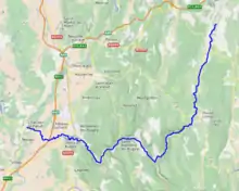 | |
| Location | |
| Country | France |
| Physical characteristics | |
| Source | |
| • location | Brénod |
| • coordinates | 46°04′41″N 05°37′07″E |
| • elevation | 873 m (2,864 ft) |
| Mouth | |
• location | Ain |
• coordinates | 45°57′54″N 05°15′27″E |
• elevation | 220 m (720 ft) |
| Length | 59.4 km (36.9 mi) |
| Basin size | 312 km2 (120 sq mi) |
| Discharge | |
| • average | 6.91 m3/s (244 cu ft/s) |
| Basin features | |
| Progression | Ain→ Rhône→ Mediterranean Sea |
Communes along its course
This list is ordered from source to mouth:
References

This article is issued from Wikipedia. The text is licensed under Creative Commons - Attribution - Sharealike. Additional terms may apply for the media files.