8th parallel south

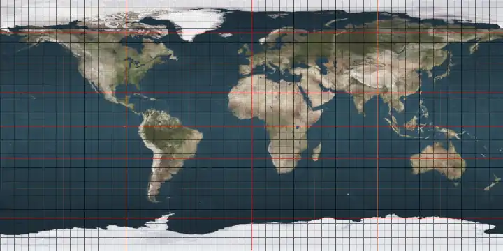
The 8th parallel south is a circle of latitude that is 8 degrees south of the Earth's equatorial plane. It crosses the Atlantic Ocean, Africa, the Indian Ocean, Southeast Asia, Australasia, the Pacific Ocean and South America.

8°
8th parallel south

Two sections of the border between the Democratic Republic of the Congo and Angola are defined by the parallel.[1]

Around the world

Starting at the Prime Meridian and heading eastwards, the parallel 8° south passes through:
Co-ordinates Country, territory or sea Notes
8°0′S 0°0′E Atlantic Ocean
8°0′S 13°11′E  Angola
8°0′S 17°29′E  Democratic Republic of the Congo
8°0′S 18°10′E  Angola
8°0′S 18°18′E  Democratic Republic of the Congo
8°0′S 18°23′E  Democratic Republic of the Congo /  Angola border
8°0′S 18°31′E  Angola
8°0′S 18°48′E  Democratic Republic of the Congo /  Angola border
8°0′S 19°22′E  Angola
8°0′S 21°46′E  Democratic Republic of the Congo
8°0′S 30°27′E Lake Tanganyika
8°0′S 30°53′E  Tanzania
8°0′S 39°27′E Indian Ocean Passing just south of the island of Mafia,  Tanzania
8°0′S 39°45′E  Tanzania Island of Chole
8°0′S 39°48′E Indian Ocean
8°0′S 110°15′E  Indonesia Island of Java
8°0′S 114°25′E Bali Sea Passing just north of the island of Bali,  Indonesia
8°0′S 117°9′E Flores Sea Passing just north of the island of Sumbawa,  Indonesia
8°0′S 122°47′E Banda Sea Passing just north of the island of Flores,  Indonesia
Passing just north of the island of Alor,  Indonesia
8°0′S 125°43′E  Indonesia Islands of Liran and Wetar
8°0′S 125°48′E Wetar Strait Passing just north of the island of Kisar,  Indonesia
8°0′S 129°39′E  Indonesia Island of Babar
8°0′S 129°48′E Timor Sea
8°0′S 131°12′E  Indonesia Island of Yamdena
8°0′S 131°19′E Arafura Sea
8°0′S 137°50′E  Indonesia Islands of Yos Sudarso and New Guinea
8°0′S 141°1′E  Papua New Guinea Island of New Guinea
8°0′S 143°55′E Gulf of Papua
8°0′S 145°48′E  Papua New Guinea Island of New Guinea
8°0′S 147°57′E Solomon Sea
8°0′S 156°31′E  Solomon Islands Island of Ranongga
8°0′S 156°35′E Solomon Sea
8°0′S 156°56′E  Solomon Islands Island of Kolombangara
8°0′S 157°11′E Kula Gulf
8°0′S 157°23′E  Solomon Islands Island of New Georgia
8°0′S 157°33′E New Georgia Sound
8°0′S 158°53′E  Solomon Islands Santa Isabel Island
8°0′S 159°24′E Pacific Ocean Passing just south of the island of Dai,  Solomon Islands
8°0′S 178°20′E  Tuvalu Nukufetau atoll
8°0′S 178°24′E Pacific Ocean The parallel defines the northern maritime boundary of the  Cook Islands from the 167th meridian west to the 156th meridian west
8°0′S 140°43′W  French Polynesia Island of Eiao
8°0′S 140°40′W Pacific Ocean
8°0′S 79°13′W  Peru
8°0′S 73°40′W  Brazil Acre, Amazonas, Rondônia, Amazonas, Mato Grosso, Pará, Tocantins, Maranhão - for about 11 km, Tocantins, Maranhão, Piauí, Pernambuco, Paraíba, Pernambuco - passing just north of Recife
8°0′S 34°50′W Atlantic Ocean Passing just to the south of Ascension Island,  Saint Helena, Ascension and Tristan da Cunha

See also

References

  1. Brownlie, Ian (1979). African Boundaries: A Legal and Diplomatic Encyclopedia. Institute for International Affairs, Hurst and Co. pp. 489–514.


This article is issued from Wikipedia. The text is licensed under Creative Commons - Attribution - Sharealike. Additional terms may apply for the media files.