Úhlava
The Úhlava (German: Angel) is a 104 kilometres (65 mi) long river in the Czech Republic, a right tributary of the Radbuza. Its source is situated on a slope of Pancíř mountain in the Šumava mountains, Klatovy District at an elevation of 1,214 metres (3,983 ft). It passes the villages and towns Nýrsko, Janovice, Bezděkov, Klatovy, Švihov, Lužany, and Přeštice before flowing into the river Radbuza at the south edge of Plzeň. Its major affluent is the Chodská Úhlava. The basin area of the Úhlava is 919 square kilometres (355 sq mi).
| Úhlava | |
|---|---|
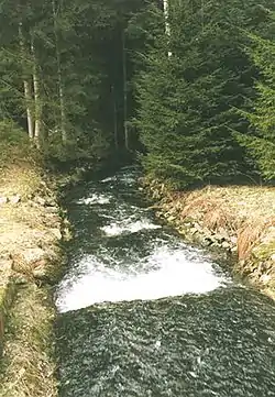 Úhlava in the Šumava mountains | |
| Location | |
| Country | Czech Republic |
| Physical characteristics | |
| Source | |
| • location | Šumava |
| • elevation | 1,110 m (3,640 ft) |
| Mouth | |
• location | Radbuza in Plzeň |
• coordinates | 49°43′14″N 13°23′19″E |
| Length | 104.0 km (64.6 mi) [1] |
| Basin size | 916 km2 (354 sq mi) [1] |
| Basin features | |
| Progression | Radbuza→ Berounka→ Vltava→ Elbe→ North Sea |
References
- Complete table of the Bavarian Waterbody Register by the Bavarian State Office for the Environment (xls, 10.3 MB)
 |
Wikimedia Commons has media related to Úhlava. |
This article is issued from Wikipedia. The text is licensed under Creative Commons - Attribution - Sharealike. Additional terms may apply for the media files.